Raja Shehadeh
It was eight in the morning when I left my house in Ramallah armed with my camera three weeks after the beginning of the Israeli occupation of the West Bank and began to cycle to Jerusalem. I had just turned sixteen and wanted to capture through photographs the damage that had been caused by the June war of 1967 to property along the Ramallah-Jerusalem road.
The road I cycled on was a minor two-lane thoroughfare built in 1901 during Ottoman times and had no military value. The approach to Jerusalem in the First World War was not through here. The Allies’ path was well to the west of this, through the village of Nebi Samuel with its imposing mosque that I was able to glimpse from various points on the road.
A few weeks earlier, on June 6, Colonel Moshe Yotvat’s brigade, entering the West Bank through Latrun, captured Jerusalem Airport without a fight. Then the Israeli army moved towards what they believed was the road to Ramallah. To be sure, they ordered an old Palestinian man to be their guide. Meanwhile the conquest of Jerusalem was proceeding through the western part of the city.
The army entered Ramallah with a battalion of tanks in the evening of that cursed day. Perhaps to our good fortune they did not wait for a bombardment to soften us up. They crossed and re-crossed the city several times shooting in every direction. We were in the house, huddled in a corner, thinking the army would break in at any moment and shoot us all. As we waited father told us: “The reason for the shooting is because the Israeli army is ascertaining whether there’s resistance.” I wondered how he knew this and was of two minds. I wanted the shooting to stop yet at the same time felt weighed down by the demoralizing expectation of defeat.
When no one returned fire the shooting stopped. There was no resistance. In a few hours the Israeli army’s conquest of my city was complete. Three weeks later I was on that narrow road cycling on my own towards Jerusalem, which had been captured a day after Ramallah fell.
For the previous 19 years of Jordan’s rule over the West Bank, this road was Ramallah’s only link to Jerusalem. Eastern Jerusalem, under Jordanian rule, provided the villages to the north with specialized hospitals, good restaurants and shopping outlets. When I was young we would take bus number 18 to get to Jerusalem. It was bedecked with signs: Do not spit, Do not talk to the driver and No smoking of Sheesha [a foul smelling cigarette filled with a cheap, highly odorous weed]. The turn signal was a manually operated metal rod. When it was returned to its place I could hear it rattle. The whole bus clanked and rumbled as it made its slow way south to Jerusalem, making it possible for me to look out of the window and observe the fields surrounding the road. My grandmother had friends in the city and I often accompanied her on her visits to them. She would warn me against touching the handrail in front of the seat because she said it was covered with germs from other passengers’ dirty hands. Money also was full of germs and I always had to wash my hands after handling it. When I was older I would take the shared taxi to Jerusalem, enjoying the drive with the lively music the driver played on his radio. I would listen to the animated passengers exchanging news about what they did on their visit to Jerusalem, being sociable, friendly and open. In warm weather I relished the clean, fresh breeze blowing, especially at dusk as the colors were changing. There was much to look at on the way, rock-strewn fields, grazing flocks of sheep, passing traffic, and the occasional fancy building proudly flanking the side of the road.
A short time after the end of the war my father was one of the first Palestinians to go back to his beloved Jaffa, though only for a brief visit. But his sister, Mary, who had stayed in Akka after the Nakba, was long gone. It was a bittersweet experience. He was realizing what for a long time he had been hoping – to see, just to see, Jaffa – and yet his return was as a defeated Palestinian who had now lost the rest of Palestine to the enemy. Jaffa was in a dilapidated state, a sad sight so unlike the vital city he remembered. When later on we visited it with him he pointed out the various cafes, once so busy, now abandoned. It was difficult for me to imagine how it must have been in the past. Perhaps the visit made him realize that there was no possibility of a real return or compensation for what he had lost. How could that be? What could possibly compensate for the years of grief and deprivation that he lived through on the other side of the border?
After leaving Ramallah I first cycled to Bireh, Ramallah’s sister city, passing by the Am’ari Refugee Camp, a crowded place with mainly concrete houses and narrow lanes where I had never set foot. I left the town and continued south to the old Ramallah-Jerusalem road.
Just after leaving Bireh I cycled past the Jubran family’s arak distillery at the Maloufieh on the outskirts of the town. Drinking arak while nibbling on the numerous small savory plates of mezza in a garden cafe was a favorite pastime for residents of Ramallah. With all cafes and restaurants now closed this pleasure was one of the casualties of the occupation and was bound to add to the mood of general gloom.
The distillery which was also shut lay at the edge of a low-lying valley surrounded by hills. Close to the top of one of these to my right stood a lonely stone house with pine trees next to which was a spring where young men came to hunt birds and visit the cave there. Just above this at the top of the hill was a plot of land father had bought with the intention of one day building a home. When he took me to see the land I had imagined the palatial house that we would someday own, perched over the hill overlooking the valley below. But mother, who did not drive, felt she would be an exile atop that hill with no neighbors around to visit and totally dependent for her coming and going on father. What also made it an unacceptable location for her was that the hill was “wilderness” and clearly unsafe. She rejected that project and the house was never built. Except for a modest winter house in Jericho, my parents could not agree on the location, size or any conception of their dream house. Nor could they agree on the sort of life they wanted to live.
After cycling some four kilometers from the start of my journey I arrived at the Samiramis Hotel on the left of the road where King Hussein was rumored to stop to rest and drink lemonade when he drove from Jerusalem for his occasional visit to Ramallah. From there a narrow road led to the attractive village of Kufr ‘Aqab up on a hill with a population of some 420. From the road the hill was visible and one could just see some of the old houses and the minaret. We later learned that one of the officers in the Jordanian army who died defending Jerusalem, Muhammad Ali Suad Jamil, came from there. Opposite the modest hotel at the intersection the road to the west led to the few houses in an area which had the unflattering name of Um Alsharayet [the mother of rags].
I cycled on passing the Jallad flour mill, one of three in the whole of the West Bank. Wheat was cultivated and ground locally, supplemented by some imports of flour. There were several sifters one on top of the other, which had become so rusty that I imagined fine rust powder rather than flour now passing from one platform to the one below. Jallad’s daughter, Claire, and her family, the Kassabs, lived across the street from us until they moved along with their factory to Amman. They had three daughters one of whom was exactly my age. They all called their father Papa not like the rest of us who said Baba. They relocated to Amman just before the occupation, as though they knew what was coming.
At the mill the road forked. I took the one going northeast. Just a few years earlier we used to drive straight ahead towards the runway of the Jerusalem Airport. When a plane was taking off or expected to land we had to wait at the barrier. We would watch the propellers turning to gather steam, then the exciting moment would arrive when the plane was ready to move and it zoomed right in front of our car and began its ascent. We also had to stop to wait for an incoming plane. I relished these delays and watched carefully every movement of the plane, trying to remember how it had felt when I was in one travelling to Beirut for vacation. I always hoped there would be a plane to watch when we passed by on our way to Jerusalem. Often when we drove on this road I would look up at the landing planes that seemed like large birds about to swoop down and land on top of our car.
Then a new by-pass was built to the east which circled around the eastern edge of the runway. This was the road I took. The triangle between the old and the new roads was full of greenery, mainly pine and citrus trees.
An Israeli customs checkpoint was checking cars for goods from the West Bank into Israel. The Israeli officials looked puzzled as I cycled past. I was not a car and it was obvious that I wasn’t carrying anything so no reason to stop me. Afterwards I passed a car on the side of the road that had been flattened by an Israeli army tank driving over it. I stopped and photographed it then continued cycling up that incline. There were more destroyed cars along the way, more expensive models than those I had seen earlier, Opels and Mercedes-Benzes. I stopped to photograph them. But this time before doing so I took my time to examine them. I was certain that they were all crushed by a tank driving over them. How does it feel to exercise the power to turn a luxury car into a flat pile of metal in only a couple of minutes, I wondered? Did the tank driver and his companions cheer every time they drove over another car? Did they then direct the driver to another car parked next to another of the posh houses on this street that they can crush? The Palestinians on this street owned far more expensive cars than was within the means of most Israelis. Did they want to destroy them out of envy, or was it revenge? We are the victors so we can do what we like to the vanquished. Was this the point when the destructive attitude that has lasted for over half a century began? And what about the owners of these cars. Did the soldiers look at the windows to see their anguished faces as they watched their prized possessions being crushed? Did they enjoy that? Surely there were elements of all these emotions present because there was no military necessity for this activity. It was merely for the recreation of the Israeli soldiers at the expense of the Palestinians. The scary thought then came to me whether from this point, having lost the war we didn’t fight, we would become like putty in the hands of the Israeli military, which started to believe that they could do what they liked with us with full impunity? The more such thoughts passed through my mind the more apprehensive I became of the future. I had to put a stop to such debilitating thoughts, and pedalled on.
Then the easternmost end of the airport runway came in sight. It was on slightly elevated ground from the road. Before I got there I passed the UNRWA Vocational Training Center across from which was Qalandia Refugee Camp, another crowded area of concrete houses crammed next to each other with narrow lanes in between. The contrast with the Center which had a lush garden was striking. I turned my eyes from the treeless area of the camp and looked through the wrought iron gate of the Center at the trees, much loved by birds which were always so plentiful on the trees that lined the long driveway leading to the school buildings, further down, that were not visible from the road. Except for the crowded camp which sloped downward to the east there were no other buildings in that area.
The refugee camp was quiet, seeming to be in deep slumber. Or so I thought. I was totally unaware then of the emotions that were raging there among the refugees of 1948 in response to Israel’s resounding victory over the Arab states. Nor was I prepared for the reactions to years of passivity that were to be sparked by the rise of the PLO abroad and the resistance to Israel. Voices would be raised that had never before been heard over the past 19 years. For now it seemed quiet, defeated, despondent. I had never been inside this or any of the other refugee camps around Ramallah. To me they were closed areas outside my scope of vision or experience. I passed so often by them yet never really saw them or was curious about the nature of life within them.
What I did see was the airport, the gateway for my anticipated escape from Ramallah, with its runway on raised ground reaching all the way to the new road that now encircled it. That new curving road built to avoid driving across the runway was poorly designed, rendering the turn dangerous if one was speeding. Father who often drove too fast once skidded on it but then managed to regain control of his car, arriving home with only a bump on his head.
Across the road I saw the blue flag of the United Nations fluttering over the camp school also painted light blue, that bordered the road. My negative view of UNRWA was influenced by father’s position towards the organization. His opinion was that it was corrupt and its main beneficiaries were the high-salaried foreign staff rather than the refugees themselves.
Immediately after the Nakba in 1948 and until 1954 my father had worked assiduously on the question of the return of the refugees. Until he gave up hope. His struggle ended bitterly. This was yet another area where he failed. 73 years have gone by and the refugees have still not returned home. By 1954 my father had come to understand that it was not only Israel whom one had to fight regarding this problem but also the Arab leaders and the UN, both of whom supported Israel in this while making a feeble effort at supporting the Palestinian cause, achieving little more than keeping the refugee issue alive.
Perhaps that was why I did not see the camps or the men, women and children living in them. Father was blocking their presence from his sight and I was following suit. This despite the fact that we ourselves were refugees from Jaffa. Yet father would not accept to register the family with UNRWA and never received any of the aid that the organization offered, so angry was he at the international organization for turning the case from one of rights to a matter of relief and humanitarian assistance, with all the consequences of long-term dependence.
Our house in Ramallah overlooked the distant Mediterranean coast and I often saw my father looking towards his Jaffa on the horizon. He must have wondered what had become of his city. I can imagine how difficult it must have been for him coming from Jerusalem to a metropolis like Jaffa where he had no contacts, setting up a law office, and succeeding. He did that then lost it all. The home he left was so close and yet so far, impossible to reach. Yet knowing him he never gave up hope. For a long time he continued to think that it was impossible that the day would never come when he would be able to return.
<pstyle=”text-align: center; white-space: pre-wrap;”>***
The ancient village of Qalandia, which gave its name to the camp that stood on land that had once belonged to it, was some distance away, out of sight from the road. In the midst of the central highlands this was an unusually flat area. This feature must have been the main consideration for situating the airport here. Bordered on the east by a small hillock, the low terrain spread eastward unimpeded. The highest and most strategic point on the horizon was the hill of Nebi Samuel, over 885 meters high, which was visible from here. Fresh gentle winds always blew across this open plain. This swath of lowland was so unlike the surrounding hilly terrain around it as to give a feel of unbounded space to the landscape.
Before the war when a plane was about to land it was not uncommon to see boys from the neighborhood standing on the hillock overlooking the eastern end of the runway to watch the aircraft landing. No buildings where allowed here. The whole area around the airport was open and airy and the runway ensured an attractive swath of empty flat land with very gentle ripples extending westward into the distance. I enjoyed cycling around the eastern tip of the airport and welcomed the opportunity of taking a closer view of the abandoned runway. After circling its eastern border the road veered towards the southwest and continued down a slight slope.
From the early days of the occupation one of the principles that served as the basis of the expansion of Jerusalem’s borders was to extend the borders of the city northward to include the Jerusalem Airport. Israel had hoped to turn this into an international airport. Although it was declared as such no country would recognize it or agree to operate international flights to or from it. This was because they refused to recognize the annexation of Jerusalem to Israel. The airport remained a small domestic facility serving regional traffic and sometimes planes used by UN officers and soldiers. Then during the first Intifada it served as a parking lot for cars confiscated by the army. There were very few houses by the side of the southward slope. As I cycled down I was enjoying the unimpeded openness of this area and the soft refreshing wind that cooled me down.
Further ahead the land to the right of the road was separated by a small basin. Nearby in an old building by the side of the road, a tense, wiry French Jew, years later, established a horseback riding school where I and a few friends learned to ride. When we got more proficient we would gallop through the hills cultivated with olive trees until we reached the steep climb up to Nebi Samuel. Along the way we had to maneuver our horses to avoid getting knocked out of our saddles by the low lying branches of the trees. It was an exhilarating ride. It was fortunate that I, an inexperienced rider, did not fall and break my back.
After 1948 and in the course of the 19 years of Jordanian rule over the West Bank with no access to the sea, roads went through the bean-shaped territory of the West Bank from north to south. The south was reached by passing through the northern section of Jerusalem then circling around the southern parts of the city which were under Israeli rule. Prior to 1948 Jerusalem had been connected to the coastal region by the road that went through Bab el-Wad. It was possible to travel to Jaffa from Ramallah without passing through Jerusalem, which really was peripheral and had no strategic importance for the rest of Palestine. But with the establishment of Israel on most of the land surrounding the West Bank, the Ramallah-Jerusalem road became vital as a main conduit between the northern and southern regions of the West Bank. As I was growing up I knew no other road for reaching Jerusalem and the cities and villages in the south other than this Ramallah-Jerusalem road that I was cycling on now. And so I was intimately familiar with every detail of this short road. This of course was not the experience of my father. How often he must have travelled from Jaffa, where he had set up his office, to see his father in Jerusalem, using the Bab el Wad road. But when he came from Jaffa to take refuge in Ramallah in 1948 he must have travelled on the road directly linking the two through Latrun. After 1948 that road was closed.
Father’s experience of Palestine was entirely different from mine. For him the whole country, the coastal region, lower and upper Galilee, Gaza and the Jordan Valley had been open, the country’s cities and villages connected by roads that didn’t have to circle around to avoid borders. I didn’t know these past connections and so didn’t miss them. How different and skewed has been my experience of the country and how reduced my existence. I grew up thinking the road I’m on now was the only road, life as I lived it in the land-locked West Bank, the only life.
With the occupation of the West Bank by Israel the whole of geographic Palestine was once again open to all the inhabitants, Palestinians and Israelis. The place reverted to how father’s generation had known it. To me and my generation it was all a new experience. Yet it was not to remain so.
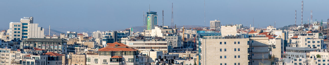
If I were to cycle now to Jerusalem I would be stopped at the Qalandia Checkpoint some 500 meters from the Vocational Training Center. This has since come to mark the border between Israel and the West Bank. It was built near the eastern side of the runway which is now enveloped by the four-meter high annexation wall. The once almost empty strips of land on both sides of the road from where the customs point had been to the Center are densely built and are in a miserable state, the road going between them constantly clogged with cars either trying to enter Jerusalem or continuing eastward to drive to the southern part of the West Bank through the village of Jaba’. As you approach the checkpoint you’re confronted by the concrete four-meter high wall that Israel built to surround the runway and separate it from the rest of the West Bank. This section is smeared with layers of graffiti. An image of Yasser Arafat wearing his kuffieh can be discerned with another of the much younger, imprisoned leader Marwan Barghouthi. The wall then continues on the other side of the checkpoint. It looks like someone had taken a felt pen and drawn a thick line around every area where Palestinians live. Then a concrete wall with watchtowers was constructed following the line encircling all the different communities and villages. What was once an open unenclosed area has been turned into a series of isolated zones, trapping the Palestinian communities and separating them from Israel.
The hill that was used by the neighborhood boys as a lookout to view the runway has been mostly leveled to accommodate the offices and parking lots associated with the checkpoint. Only a small part of the hill remains, the rest is gone, transforming the area from an attractive expanse of land into one that is strangled by the wall with its watchtowers. From the road no part of the runway is now visible.
Qalandia Checkpoint has become the new Mandelbaum Gate which used to separate the two parts of Jerusalem. This barrier separates the West Bank from the expanded borders of eastern Jerusalem. Israeli fears of and callousness towards the Palestinians are amply evident here, both in the way the wall is designed and in the path its takes. It is a far more formidable wall than that which had marked the division of Jerusalem after 1948. It has Israeli soldiers on both sides. Holders of Jerusalem residency cards are the only ones allowed to pass through the crossing point. Cars with West Bank license plates can no longer cross and must drive east. They must circle around expanded Jerusalem through the newly constructed bypass road that skirts the village of Jaba’, then drive southward through Wadi Nar [valley of fire], never entering any part of expanded Jerusalem or the surrounding villages that were annexed to the city after 1967. Often the road from Ramallah leading to Qalandia gets clogged up with the lines of cars reaching all the way to Kufr Aqab which I had passed near the start of my cycling journey.
A short time after I cycled past Kufr Aqab, Israel annexed this sparsely populated hamlet along with 28 others, joining them with Jerusalem. The annexation followed a haphazard line avoiding the areas most populated by Palestinians while including undeveloped Palestinian land. The western side of the road I was cycling on was incorporated within the city while the eastern side including the refugee camp remained in the West Bank. This meant that those living on the eastern side of the road were considered residents of Jerusalem but not those on the western side.
The new border of expanded Jerusalem reaches to the outskirts of Bireh. Kufr Aqab and sections of Um Alsharayet where only a scattering of houses once stood were included in greater Jerusalem. With the scarcity of housing for Palestinian residents of the city, over the years many Palestinian residents who needed to live within the boundaries of Jerusalem to avoid losing their status as residents moved to these areas, causing a building boom and turning Kufr Aqab and Um Alsharayet, which the Israeli authorities did not care to plan properly or to prevent building violations in the area, into virtual urban jungles. The mass of new buildings has swamped the small attractive village that I could see in 1967 at the top of the hill to the east as I cycled by. This was also the fate of that solitary house on the hill surrounded by the pine trees on the western side of the road where father’s land lay. All the trees there were felled and replaced with a forest of stone buildings standing next to each other. It was fortunate father had not built a house there.
That morning in June 1967 as I headed to Jerusalem I could not have anticipated that the Mandelbaum Gate that stood between the eastern part of Jerusalem that I grew thinking of as my Jerusalem, and the western part under Israel which was totally unknown to me, would come to be moved to Qalandia, as had the wall that until 1967 divided the eastern part of Jerusalem under Jordan from the western part under Israel.
My father had had his share of harsh experiences at that gate. His sister was living in Akka (Acre) and he could only see her at Christmas if she managed to get a permit from the Israeli government to cross over for a few days to celebrate the feast with us in Ramallah. The anxiety-ridden memories of that must have been on father’s mind when he heard of his brother’s crossing to Amman. He feared being separated from and losing his brother as he had lost his sister. How would it be now, what would it take to get to see his brother again for a visit? Whom would he have to petition to obtain the necessary permits? Now once again his brother was forcing him into the position of a petitioner asking for favors to allow his return from across the new border. This made him very angry.
But I understood none of this that morning in June when I cycled to Jerusalem.
After passing the eastern tip of the runway I coasted quickly down the slope where there were no houses on either side of the road. This brought me to the “Halfway Bridge”, so called because it is halfway between Ramallah and Jerusalem. By then I had cycled around six kilometers, almost half the distance to Jerusalem.
The June sun was getting stronger but a refreshing cool breeze continued to blow. In rainy weather a good stream flows under the bridge. The small village of Er-Ram [small hill] rests on a mound just beyond this bridge to the north. By the side of the road near Er Ram is a cluster of new houses known as Dahiet El Bareed [postal service district]. This was one of the rare housing cooperatives and it belonged to employees of the postal service in Jerusalem. The same man who was behind this pioneering initiative had also promoted another housing cooperative on a flat tract of land some four kilometers from the center of Jericho on the way to the Jordan River. Father had joined this project. After many years the cement houses each with a garden all around were completed. It was 1962 when our family became the owners of a winter house in the warm climate of Jericho in which we spent weekends whenever we could manage it. I kept a bicycle there and would ride it around the project on the flat land that was so unlike hilly Ramallah. At times I would cycle all the way down to the banks of the Jordan River. We spent many a happy weekend in our winter house. Its garden had all kinds of citrus trees and vegetables which with the mild winter and plenty of water grew like magic, so unlike our garden in Ramallah where the pine trees made the soil acidic. After the 1967 war we got news that the house had been broken into and looted. A number of the middle-class families who owned houses there were from Amman and now they would surely not be able to use their homes. Many other owners from the West Bank had also left for Jordan. There was a sharp depletion in the middle class after the war. As is often the case they are the first to desert. As for us, those times when we moved in winter between Ramallah and Jericho along with other family friends would surely also come to an end as will my excursions to the river, the new formidable, unapproachable frontier. Such was the expected disruption of our old way of life with the onset of the Occupation.
Close to Dahiet El Bareed along the other side of the road, was the village of Bir Nabala with its many springs and rich agricultural land hence its name which means the well of Nabala. This village was reachable via a slight detour from the Ramallah-Jerusalem road.
For a number of years the Halfway Bridge was the location of the checkpoint before it was moved further north to Qalandia.
I remember when the Annexation Wall was being built along this road. I saw the first blocks of concrete being placed right in the middle of the road. I didn’t believe that was where they were going to build it. I thought it’s impossible that it could be built there. Of course that was where it was actually erected and where it has remained.
This section of the Annexation Wall which begins at Qalandia continues southward, bifurcating the Ramallah-Jerusalem road right in the middle. Travelers to Jerusalem now drive in the shadow of the Wall. At the bridge it curves eastward separating Er Ram from Dahiet El Bareed and encircling the former, leaving it on the West Bank side. It then continues eastward keeping the settlements of Nevi Samuel on the Israeli side and the Palestinian village of Jaba’ on the Palestinian side. It also stretches westward blocking the entrance to Bir Nabala and encircling the town. Above that closed entrance a highway passes connecting the Jerusalem settlements to Tel Aviv and the coastal region. In that cul-de-sac an Israeli company, GreenNet, operates a large facility sorting the waste collected from Jerusalem. A permanent foul smell permeates the area.
Before the wall was built, the town of Er Ram had grown from a small attractive village on top of a small hill (hence its name) into a sprawling small city where many of Jerusalem’s Palestinian residents reside because of the shortage of residential homes for Palestinians in eastern Jerusalem. Now that Er Ram lies entirely behind the wall, in the West Bank, those who wanted to keep their Jerusalem residency had to leave and find a place to live within the area recognized as Jerusalem. The exact same fate has befallen Bir Nabala.
As I write this, 53 years later, the area where the Qalandia Checkpoint stands that used to be an open space, caressed by a soft wind, affording a welcome contrast to most of the landscape surrounding it, has now been transformed into a dirty, tortured place, littered with trash, enclosed by a wall smeared with graffiti, shackled by gates and miserable turnstiles too narrow to allow easy passage for many pedestrians who are oversized. The Jerusalem Airport runway has become a parking lot hemmed in by the Annexation Wall and no longer visible from the road. Plans are in the making for the construction there of housing for Israeli Orthodox Jews to complete the encirclement of eastern Jerusalem by Jewish settlements
When Israel decided to close off Jerusalem from the West Bank after 1991 the process was gradual. At first they put the checkpoint much further to the south. It slowly crept further north, moving closer to Ramallah until it settled in its present position in Qalandia where it assumed the role that the Mandelbaum Gate once played—only this time it has Israeli soldiers on both sides of the checkpoint which has come to separate the expanded Jerusalem under Israel from the West Bank.